
A rapidly intensifying system threatens the East Coast.

The storm racing up the Eastern Seaboard today is strengthening at a pace that has startled forecasters, pushing more than fifty million people into its expanding danger zone. What began as a winter nor’easter has deepened so quickly over the Atlantic that it is expected to cross the threshold into a bomb cyclone tonight. Officials from North Carolina to Maine are bracing for a night of flooding, outages and sudden shifts that make planning difficult.
1. Pressure is plunging at a dangerous rate.

Meteorologists tracking the storm saw pressure drops steep enough to indicate explosive deepening according to NOAA. That shift forced early morning forecast maps to be redrawn as the storm gained energy from warm Atlantic waters. The rapid intensification triggered upgraded coastal advisories across several states as winds began rising hours earlier than expected.
Residents in towns like Scituate, Salisbury and Atlantic City felt conditions change almost minute by minute. Gusts climbed fast and the ocean pushed higher onto roads even with the storm center still offshore. Local officials urged people to move cars to higher ground and avoid waterfront areas as the pressure fall signaled a storm capable of evolving unpredictably.
2. Millions are now within the expanding wind field.
Forecast models showed the wind field stretching farther inland, creating a much wider zone of impact as stated by AccuWeather. This meant millions of people who were not in the high risk area yesterday suddenly found themselves facing damaging wind potential today. Emergency managers in multiple states began preparing for extensive treefall and grid disruptions.
School districts from Long Island to coastal Connecticut announced closures as transportation agencies warned passengers about delays. Rail platforms filled with commuters trying to reach home before the worst bands arrived. The rapid expansion of the wind field added urgency to local planning since outages could spread quickly through heavily populated corridors.
3. Coastal flooding concerns escalated dramatically.
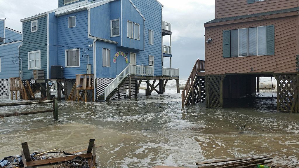
New tidal models released midday indicated that several coastal communities could see water levels higher than their previous winter peaks as reported by the National Weather Service. Surge estimates rose sharply once the storm’s strengthening trajectory became clear. Towns along the Jersey Shore and southern New England began reinforcing barriers as water pushed inland faster than the tide cycle usually allows.
Low lying neighborhoods saw streets flood well before the worst conditions arrived. Residents in places like Rehoboth Beach and Wickford moved belongings upstairs as emergency crews warned them that the evening high tide would likely be significantly worse. The combination of rising surge and incoming wind shifts created a chaotic set of overlapping threats.
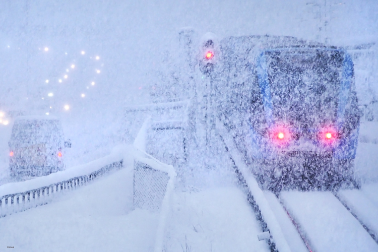
4. Snow bands intensified as the storm deepened.
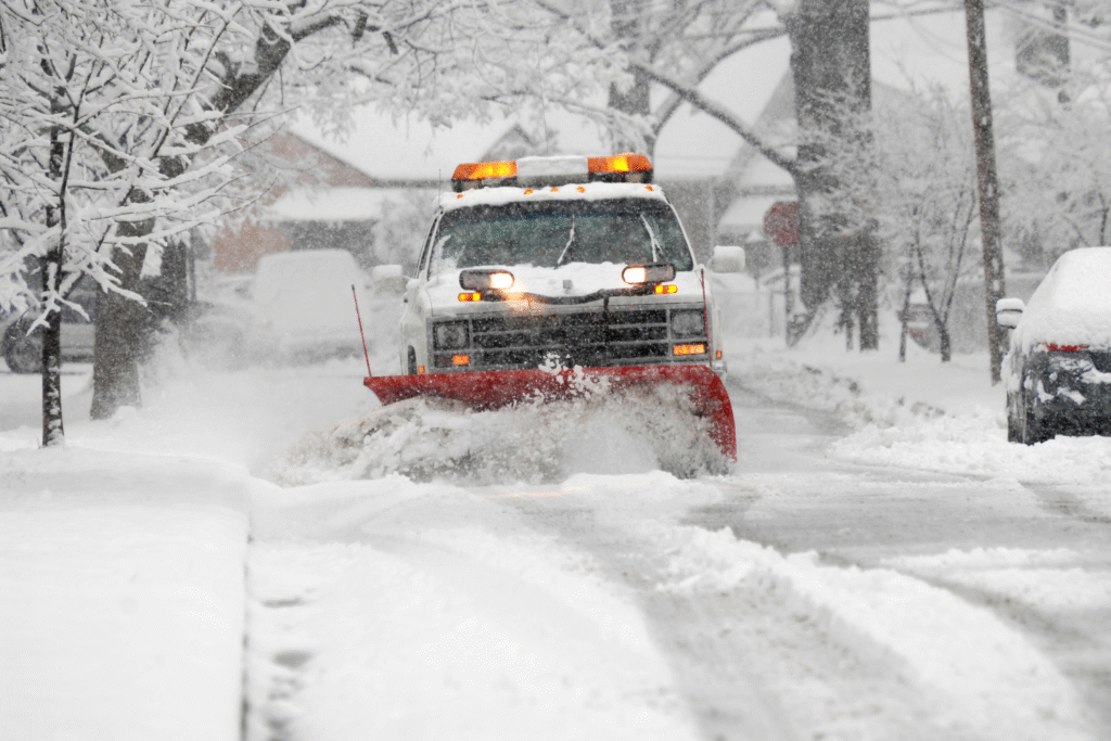
Cities farther inland watched the rain snow line swing wildly as the system strengthened. Meteorologists warned that heavier bands could set up over central Massachusetts, inland Connecticut and southern New Hampshire as cold air wrapped in behind the low. The snowfall totals that were expected to be modest earlier in the week suddenly looked far more serious.
Highway crews scrambled to pre treat roads before the temperature dropped. Drivers in Worcester and Hartford already experienced slushy patches forming despite daytime warmth lingering. That quick transition signaled a night of hazardous travel, especially in regions unprepared for the sudden jump in accumulation.
5. Flight networks collapsed under cascading delays.

As winds approached hazardous levels near major hubs, airlines began issuing ground stops to avoid dangerous takeoff and landing conditions. Airports in Boston, Newark and Philadelphia saw delays stretch into hours, creating a ripple effect across the national flight grid. Passengers trying to reroute north or south encountered few options.
Terminal hotels booked rapidly as travelers gave up on same day departures. Crews stuck on delayed aircraft pushed schedules even further into the night. The speed of the storm’s intensification made it nearly impossible for airlines to adjust without widespread cancellations across the eastern half of the country.
6. Power outages rose as trees buckled in gusts.
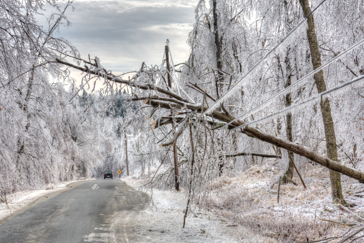
Utility companies across multiple states warned customers that outages could become prolonged as saturated soil combined with high winds. Early gusts toppled trees in Maryland and Virginia before the storm even reached peak strength. Repair crews struggled with the pace of calls as new outages appeared within minutes.
Emergency managers asked families to charge devices and prepare backup lighting. Neighborhoods in coastal zones lost power midday, forcing residents to rely on community warming centers. The worsening wind forecasts suggested that overnight restoration could become impossible for many affected regions.
7. Coastal towns braced for dangerous overnight tides.

Towns along Cape Cod, Long Island and the Jersey Shore prepared for high tide cycles that would occur at the storm’s peak strength. Officials warned that a rapidly deepening low combined with an already elevated Atlantic could overwhelm dunes and seawalls. Boats were moved from exposed marinas as water rose into parking lots.
Emergency responders positioned vehicles on higher ground in case roads became impassable. Residents accustomed to winter storms sensed the unusual nature of this one as water reached curbs far earlier than typical. The displaced ocean height signaled a surge event likely to test fragile infrastructure.
8. Storm timing disrupted weekend travel across states.
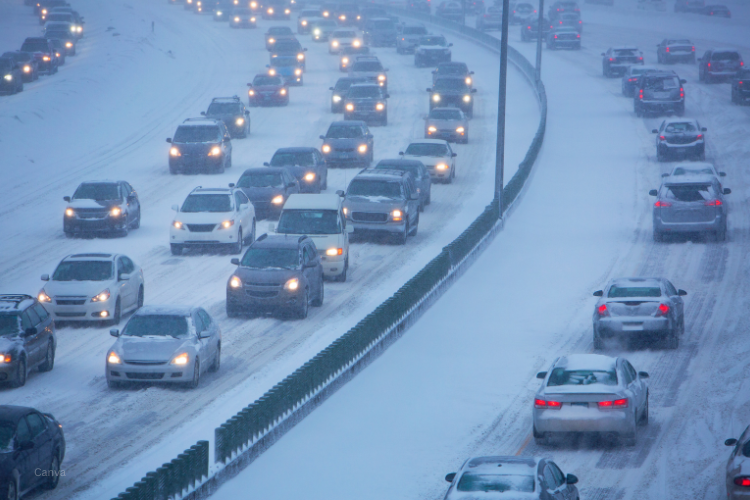
What was supposed to be a manageable winter system collided with the busiest weekend shopping and travel period of the month. Highways leading into Boston, Providence and New York saw backups as people tried to reach home before conditions deteriorated. GPS maps filled with closures once local flooding began.
Delivery trucks were rerouted around impassable areas, delaying shipments during a time when logistics networks are most strained. Families attempting holiday visits adjusted plans on the fly as the storm forced unpredictable travel patterns. The timing complicated decisions for anyone living near vulnerable roads.
9. Emergency shelters opened as conditions worsened.

Local governments across several states activated emergency warming centers to prepare for extended outages. Residents relying on electric heat or medical equipment were encouraged to relocate before winds reached their most dangerous levels. Weather officials urged people who live alone to check in with neighbors in case communication networks faltered.
Shelters in Portland, Providence and coastal New Jersey saw rising numbers by late afternoon. Families sought refuge from cold rain, rising tides and the risk of falling trees. Volunteers worked quickly to coordinate supplies as the storm’s second wind field pushed inland.
10. Officials warned the storm could shift again tonight.

Meteorologists emphasized that rapidly intensifying systems can change structure unpredictably once they reach bomb cyclone thresholds. Forecasters urged residents across the Northeast to stay alert for new advisories since minor track shifts could drastically change local impacts. Emergency alerts remained active across every coastal state as the low continued deepening offshore.
Communities already facing flooding or outages worried about additional wind bursts still developing around the storm. Throughout the evening, officials repeated that the storm’s evolving nature made it especially important to stay updated. Millions remained directly in its path as the night progressed.