
The first Atlantic hurricane of 2025 rewrote the rules of storm intensification.

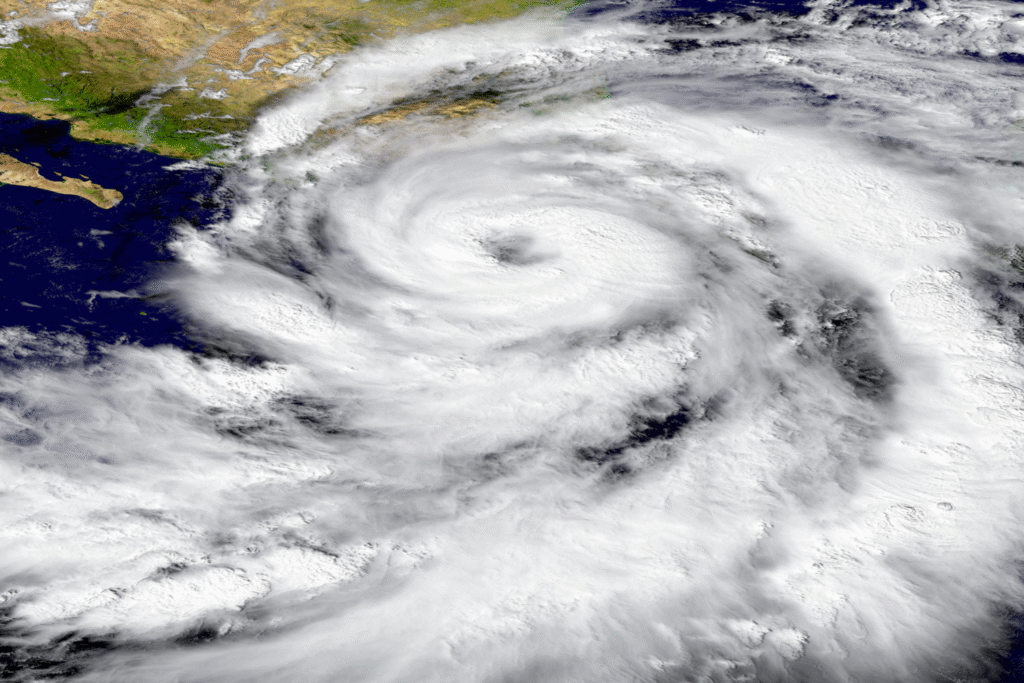
Hurricane Erin’s transformation from tropical storm to Category 5 monster in just 24 hours represents one of the fastest intensification rates ever recorded in the Atlantic basin, stunning meteorologists and forcing scientists to confront uncomfortable realities about how climate change is supercharging storm development. The storm’s explosive growth from manageable weather system to apex predator occurred with a speed that left forecasters scrambling to issue warnings and coastal communities with dangerously little time to prepare.
What makes Erin particularly alarming isn’t just its record-breaking intensification rate, but how it demonstrates that the extreme weather events climate scientists predicted are happening with increasing frequency, suggesting that rapidly intensifying storms are becoming a regular feature of Atlantic hurricane seasons rather than rare exceptions.
1. Erin gained 85 mph in wind speed during a single 24-hour period.
The storm’s explosive intensification from 70 mph tropical storm winds to 160 mph Category 5 hurricane winds occurred in just over 24 hours, representing one of the most dramatic strengthening episodes ever documented in the Atlantic basin and placing Erin among the five fastest storms to grow from Category 1 to Category 5 status in recorded history. This extraordinary rate of development caught forecasters off guard and demonstrated how quickly modern storms can evolve from manageable threats to unsurvivable disasters in timeframes that challenge traditional warning systems.
According to Wikipedia’s documented analysis of Hurricane Erin, this 24-hour intensification was the greatest of any Atlantic hurricane on record based on drop in central pressure before September 1, establishing new benchmarks for rapid storm development that meteorologists will use to understand extreme weather patterns. The speed of this transformation left emergency management agencies with compressed timelines for issuing warnings and forced coastal communities to prepare for a Category 5 storm when they had initially been tracking a much weaker system.
2. Only eleven other Atlantic hurricanes have reached similar strength this early in the season.

Achieving 145 mph winds or stronger by mid-August places Erin in exceptionally rare company among Atlantic hurricanes, with only eleven other storms reaching comparable intensity this early in the hurricane season since records began in 1851, demonstrating how unusual it is for storms to reach peak strength during what historically were considered moderate-risk periods. The early-season timing of Erin’s extreme intensity challenges traditional assumptions about hurricane seasonal patterns and peak activity periods that have guided emergency preparedness for generations.
Since records began in 1851, there have only been 11 other Atlantic hurricanes that have had 145 mph winds or stronger by this point in the season, as reported by NOAA’s National Environmental Satellite Data and Information Service, highlighting how Erin’s combination of timing and intensity represents a convergence of factors that creates new categories of risk for coastal communities. This early-season strength suggests that the traditional hurricane calendar may be becoming obsolete as climate change extends periods of dangerous storm development throughout longer portions of the year.
3. Climate change made Erin’s intensification conditions up to 100 times more likely.
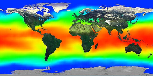
The exceptionally warm ocean waters that fueled Erin’s rapid strengthening were made significantly more probable by human-caused climate change, with sea surface temperatures averaging 2°F warmer than they would have been without anthropogenic warming, providing the thermal energy necessary for the storm’s explosive development over a 24-hour period. These elevated ocean temperatures created perfect conditions for rapid intensification that would have been virtually impossible under pre-industrial climate conditions.
According to Climate Central’s analysis, the ocean temperatures along Erin’s intensifying path were made up to 100 times more likely due to human-caused climate change, and these conditions strengthened Erin’s top wind speed by about 9 mph, transforming what would have been a Category 4 storm into a Category 5 monster with significantly higher destructive potential. The climate fingerprint on Erin’s intensification demonstrates how global warming is directly amplifying hurricane intensity through measurable changes in ocean thermal energy that storms can access for rapid development.
4. Rapid intensification is becoming increasingly common in Atlantic hurricanes.

Episodes of rapid intensification, defined as wind speed increases of at least 35 mph in 24 hours, have become far more frequent in recent decades as warming ocean temperatures provide more energy for explosive storm development that can catch forecasters and emergency managers unprepared for sudden intensity changes. Modern hurricanes regularly undergo these dramatic strengthening periods that compress traditional warning timelines and challenge prediction models designed for more gradual storm evolution patterns.
Studies published by WUSF indicate that rapid extreme intensification is becoming more common this century, with over a dozen storms intensifying at least 58 mph in a day during recent decades, demonstrating how climate change is fundamentally altering hurricane behavior patterns that emergency management systems were designed to handle. The increasing frequency of rapid intensification events creates ongoing challenges for meteorologists trying to provide accurate intensity forecasts and for coastal communities attempting to prepare for storms that can dramatically strengthen with little advance warning.
5. Erin’s pressure reading ranks among the most intense Atlantic hurricanes ever recorded.

The storm’s minimum central pressure of 915 millibars during peak intensity places it among the 21st most intense Atlantic hurricanes in a database containing nearly 2,000 storms, demonstrating the extraordinary power that Erin achieved during its brief period at Category 5 strength. This pressure reading indicates the tremendous energy concentration within the storm’s core and helps explain the explosive wind speeds that developed so rapidly during the intensification process.
The pressure measurements taken by Hurricane Hunter aircraft during Erin’s peak intensity phase provide crucial data for understanding how rapidly intensifying storms achieve such extreme power levels in compressed timeframes. These readings contribute to the scientific understanding of storm dynamics and help meteorologists refine their predictions for future rapidly intensifying hurricanes that may exhibit similar pressure characteristics during explosive development periods.
6. Forecasting models struggled to predict Erin’s explosive strengthening accurately.

Traditional hurricane prediction models consistently underestimated the rate and extent of Erin’s intensification, with most forecasts calling for gradual strengthening over several days rather than the explosive Category 5 development that occurred within a single day. The modeling challenges highlight ongoing difficulties in accurately predicting rapid intensification events that are becoming more frequent as climate change alters the atmospheric and oceanic conditions that govern hurricane behavior.
According to NBC News reporting on the storm, the process of rapid intensification remains difficult to forecast, and scientists know that while warm sea surface temperatures, moist air and favorable atmospheric conditions are necessary, understanding how it will happen for specific storms requires more research. The forecast failures surrounding Erin demonstrate the gaps that remain in meteorological understanding of how climate-enhanced storms behave under current atmospheric conditions that differ significantly from historical patterns.
7. Emergency evacuations were ordered despite the storm remaining offshore.

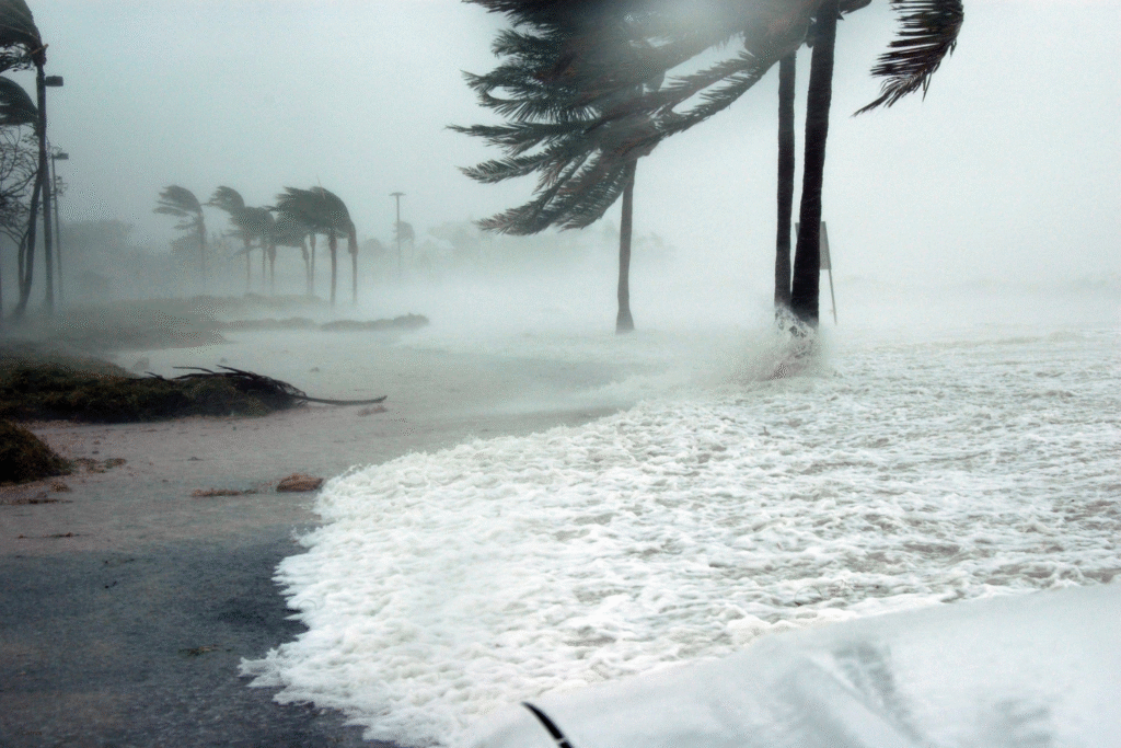
Even though Erin never made direct landfall, its massive size and intensity prompted evacuation orders for North Carolina’s Outer Banks and emergency declarations from state governments concerned about the storm’s indirect impacts on coastal communities. The hurricane’s enormous wind field, extending nearly 575 miles across at one point, created dangerous conditions far from the storm’s center and demonstrated how Category 5 storms can threaten vast areas even when remaining over open water.
The evacuation orders and emergency preparations for an offshore storm highlight how modern hurricanes have grown larger and more powerful, creating threat zones that extend hundreds of miles from their centers and affect coastal areas that might have been considered safe during smaller historical storms. Emergency management agencies found themselves preparing for impacts from a storm that wouldn’t technically make landfall but still posed significant risks to millions of people along the Eastern seaboard.
8. Erin generated dangerous conditions across thousands of miles of coastline.

The hurricane’s massive wind field and intense core produced life-threatening surf, dangerous rip currents, and coastal flooding from the Caribbean through the U.S. East Coast to Atlantic Canada, demonstrating how a single storm system can impact enormous geographic areas when it reaches extreme intensity levels. These widespread impacts occurred despite the storm remaining offshore, showing how Category 5 hurricanes can affect entire ocean basins and multiple countries simultaneously.
According to NASA Earth Observatory documentation, forecasters warned of dangerous surf and rip currents, flooding, and beach erosion along the Eastern Seaboard as Erin approached, emphasizing how the storm’s effects extended far beyond its immediate path. The extensive geographic reach of Erin’s impacts illustrates how climate-enhanced hurricanes can create regional-scale disruptions that affect multiple nations and require coordinated international response efforts even when the storms don’t make direct landfall.
9. The storm caused significant infrastructure impacts despite staying offshore.
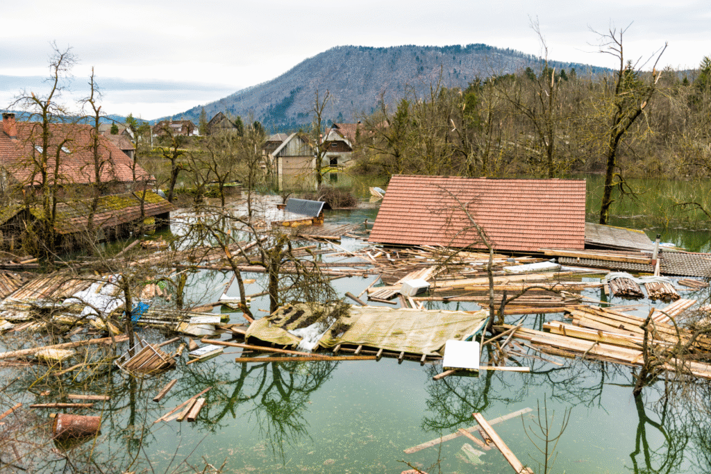
Erin’s outer bands and large wind field caused widespread power outages affecting over 250,000 residents in Puerto Rico and the Virgin Islands, along with flooding, flight cancellations, and dangerous seas that disrupted commerce and daily life across the Caribbean and along the U.S. coast. These impacts occurred while the storm’s center remained hundreds of miles from major population centers, demonstrating the expanded destructive reach of modern Category 5 hurricanes.
According to reports from Caribbean tourism authorities, the storm brought power outages, flooding, and dangerous seas across the Caribbean and Bahamas, highlighting the importance of preparedness across the region even for storms that don’t make direct landfall. The infrastructure damage from an offshore storm shows how the increasing size and intensity of modern hurricanes creates new categories of risk that emergency planners must consider when preparing coastal communities for hurricane season.
10. Erin represents the new normal for Atlantic hurricane behavior.
Hurricane Erin’s rapid intensification, early-season Category 5 strength, and massive size exemplify the characteristics that meteorologists expect to see more frequently as climate change continues to warm ocean waters and alter atmospheric patterns that govern hurricane development. The storm’s behavior patterns match scientific predictions about how hurricanes will evolve in a warming world, suggesting that Erin-like events will become routine rather than exceptional during future Atlantic hurricane seasons.
According to Virginia Tech meteorology experts, as sea surface temperatures increase, hurricanes are expected to have more energy to support higher intensification rates, and rapid intensification like Erin’s is becoming more common than in the past. The transformation of hurricane behavior from predictable seasonal patterns to increasingly extreme and rapidly developing storm systems represents one of climate change’s most immediate and visible impacts on weather patterns that affect millions of people living in hurricane-prone areas along Atlantic coastlines.
58ctz4